
Dospat Municipality is the westernmost municipality in Smolyan Province, southwestern Bulgaria, bordering on Greece. It is the site of Dospat Dam, the largest dam in Bulgaria.
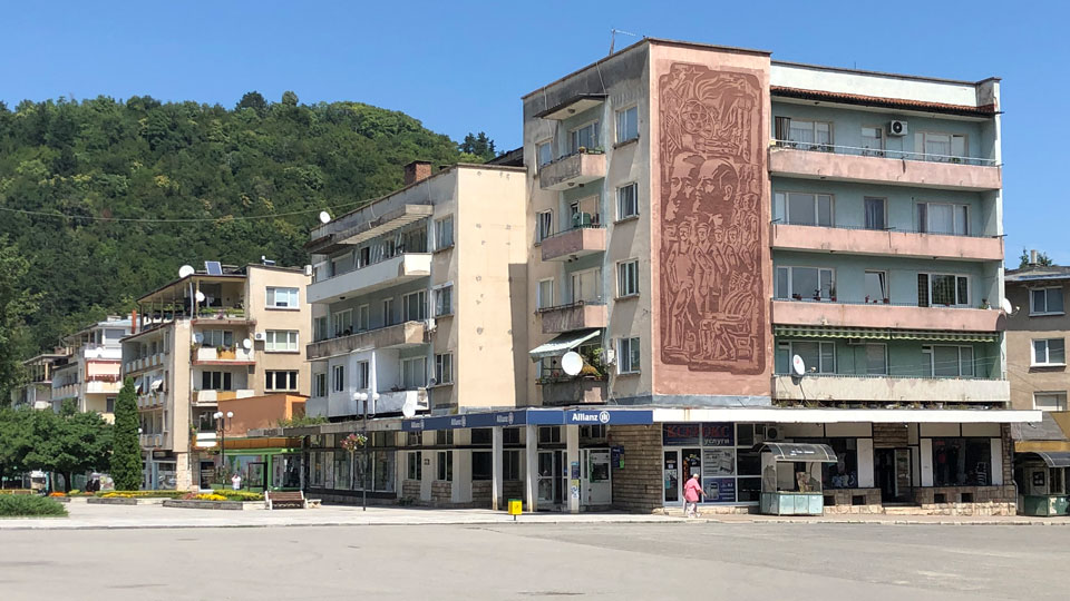
The administrative center of the municipality is the city of Dospat.
Dospat Municipality Contact Details:
Dospat Municipality
3 Parvi May Street
4831 Dospat
Bulgaria
Tel: +359 (0)3045 2310
Fax: +359 (0)3045 2312
Email: obshtinadospat@abv.bg
History of Dospat Municipality
Remains from the 4-5th century BC were found in the vicinity of the town. Early ceramic fragments from the Slavs were discovered near Dospat. [5]
An Ottoman list of settlements and the number of non-Muslim populations in them from Plovdiv and Pazardzhik dated February 28, 1651 indicates that three non-Muslim families, taxed by jizia, live in Dospat (Dospodlu). [6]
According to Stefan Zahariev, by 1850 there are 40 Pomak houses and 130 Pomak residents in Dospat (Despotovo). [7] In 1895, Dospat was burned during the so-called Chetnik Action of the Macedonian Committee. [8] During the Balkan War, soldiers from the 9th Plovdiv Infantry Regiment slaughtered 40 troops who served on a local farmstead. The Ratai were buried in a mass grave in the Ratai grave site. [9]
In a document from the Main Mufti of Istanbul, listing the waqfs in the Principality of Bulgaria, they contributed to the benefit of Islamic religious, educational and charitable institutions in the 16th century – 1920, drawn up in the period from 15.09.1920 to 03.09.1921, as a waqf village. also mentions Dospat. [10]
There are records suggesting that Turks working in the administrative unit or soldiers in a military garrison in or near the village lived in Dospat in the past. [11] After the Russo-Turkish War (1877-1878), the town of Tatar Pazardzhik, to which Dospat and the surrounding villages belong, falls into Eastern Rumelia, which is why Dospat goes to the Nevrokopskaya River, where it remained until 1912, and after 1912 became a municipality in Pashmakliiska the surrounding area.
Following the baptism of late 1912 and the outbreak of the Inter-Allied War in 1913, a troop was organized in Dospat to counter the various Hajduk troops. Thus, Dospat contributes to the rebellion that gave birth to the so-called. The Republic of Gümürgin. [12] The Dospat detachment works together with the troops from the villages of Vaklinovo, Lyubcha, Valkosel and Kochan. These troops consisted of 30, 50 or 60 people each. On the night of 26 September 27, 1913, they attacked the border guard station in the village of Chavdar. [12] In addition, the village priest and secretary-tax collector were killed. [13]
According to census data in the years 1926, 1934, 1946, 1956 and 1965, the population of Dospat was 932, 1026, 1394, 1884 and 2421, respectively. [14]
In passing the Renaissance process, the authorities chose to first change the names of the residents of Barutin, since the Dutches were more fanatical. After the dampening of the passions in Barutin, the population of Dospat is frightened and therefore no serious incidents occur. The operation was led by officers Zafirov and Kasapov of the Ministry of the Interior in Devin.
The village was declared a city by Decree 1942 of the State Council of People’s Republic of Bulgaria of September 4, 1974 (promulgated, SG, issue 72 of 17.09.1974).

Geography of Dospat Municipality
Berkovitsa Municipality covers an area of 464 sq km. It is the southernmost municipality of Montana Province. It lies on the northern slopes of the western Balkan mountains, with hilly terrain broken up by streams flowing through its territory. The area is rich in wildlife and vegetation, with blueberries and raspberries filling the stomachs of many a wanderer during long summer afternoons.
There are 20 villages and towns in the municipality with a total population of about 18,000 people. Almost 75% of the population, over 13,000 people, reside in the town of Berkovitsa. Barziya, population 1400, and Zamfirovo, population 1200, are the only other villages of any size. None of the rest rises above 300 souls. They include Balyuvitsa, Bistrilitsa, Bokilovtsi, Borovtsi, Chereshovitsa, Gaganitsa, Komarevo, Kostentsi, Kotenovtsi, Leskovets, Mezdreya, Parlichevo, Pesochnitsa, Rashovitsa, Slatina, Tsvetkova Bara, and Yagodovo.
Economy of Dospat Municipality
The economy of Dospat is mainly focused on potato production, timber production, woodworking and light industry – production of wool knitwear, footwear production. Tourism is developing in good directions. In recent years, the attraction of the boat and water sports service at the Dospat Dam has been a great attraction. In the summer, some residents make a living by harvesting wild mushrooms, herbs and fruits (blueberries, raspberries, blackberries, wild strawberries). In principle, the economy of the municipality as a whole is declining due to poor working conditions offered by employers. Textile shops in the surrounding area are attracting cheap labor. There is no well-developed strategy for investment policy by governing local structures. Small family-run hotels operate.
Tourism in Dospat Municipality
Tourism / Attractions:
1. Dospat Dam. Dospat is a dam on the Dospat River in the Western Rhodopes. Situated at 18.3km² at 1200m altitude and is among the largest in area and volume in Bulgaria. At the time of its construction, the Dospat Dam is the second largest dam in the country. The dam is 19km long and about 1km wide, located northwest – southeast. On its northeast coast a picturesque road passes between the towns of Sarnitsa and Dospat.
The lake is rich in fish. In it swims perch, carp, mullet, boar, redfin and trout. There are excellent conditions for the development of sport and commercial fishing. All kinds of fishing are practiced.
2.Sport Hall – Dospat – the largest sports hall in the Western Rhodopes, built in 2015. The hall has a swimming pool, many playgrounds, a gym.
3. Tourist Information Center – Dospat – The Center operates without rest and is in close proximity to the Sports Hall. It has a rich showroom and local folklore exhibit. The center provides information for all tourists, guests of Dospat and the Municipality.
4. Ecopark – located in Keltepe area, above the town of Dospat. There are many alpine trails, a summer scene and attractions – swings, slides and sports facilities.
5. Coastal alley – Dospat – is located on the east coast of the city, it is signaled and illuminated at night. Also called the “Little Bosphorus”. The alley itself is 2120 m long and three meters wide. There are drainage ditches everywhere. Along its length are evenly spaced: octagonal arbor, arbor with barbecue, two fireplaces, tables with benches, playground. The alley is for pedestrians only, with a sign prohibiting the passage of vehicles. The real attraction from which the comparison with the Bosphorus comes is in the evening, when the solar lamps, which are close to 200, shine. The promenade comes alive with tourists.
5. Rhodope Fountain Park Museum: To make the city an attractive place for tourism and to enrich the city center with an attractive and educational place for recreation Dospat Municipality has created a unique park for Bulgaria.
Outdoor park with exhibits (models) of wettable specimens of Rhodope fountains from the territory of Dospat municipality. The site is located on the northern slope of the wooded hill, located in the heart of the city, near the City Stadium and the Sports Hall.
In addition to the magnificent views that the hill reveals, the picturesque northern slope is the first landscape that visitors see after entering Dospat.
One of the goals of the park is to show the guests and the residents of the town and to get acquainted with the craft of “Fountain” and the Rhodope tradition of giving a fountain.
6. “Cracked stone” near Barutin village: “Cracked stone” is on the road, which in the past connected the people of Northern Greece with part of southern Bulgaria in the Western Rhodopes. The road was mainly used by merchants. It is a huge rock of two parts, cut like a knife into two halves, about 3 meters apart. There is a legend about this stone that is very interesting: http://dospatnews.blogspot.bg/2017/04/blog-post_46.html.
7. Kavaka – A landmark in the village of Barutin, Dospat municipality is a centuries-old poplar located in the village’s Upper neighborhood. The poplar is also called – Kavaka.
8.Vaklinova hammer peak – Brashten village – a memorial plaque was built here in memory of Vergil Vaklinov and his dog Vihar. The Vaklinova hammer locality is about 2km east of Brashten village.
9. Roman bridge of Dospat Dere – it is located above the river Dospat and is between the villages Brashten and Tsrancha. Memorial plaques of Vergil Vaklinov and Doncho Ganev were built here. Annually, in the beginning of July, wreaths and flowers are served on the plots at Mount Vaklinova hammer and at the Roman Bridge. The event was initiated by the Bulgarian Border Guards Forum – a community of soldiers, sergeants and officers who served in the Border Troops and Border Police, united by the idea that it is worthy of everyone to be a defender of the Motherland.
10. The rock near the village of Tsrancha – a unique rock complex, which is considered to have been a sanctuary in the past. The attractiveness of the Skeleto comes from a wedged rock in a circular form between two rocks, separately revealing unique panoramic views. The landmark of Skaleto is 1.5 km from the village of Tsrancha. In the village itself, the school has a museum collection that tourists do not miss seeing.
11.Dragieva Fountain – Chavdar: The famous Dragieva fountain is included in the developed tourist routes and tourists are not missing in the summer. The tap is located on the village square next to the Town Hall. It was built in 1934 by Captain Dragiev, commander of the border guard village of Chavdar. In Chavdar there is a legend about Dragie’s fountain.
From the Dragiyev fountain there is a sports trail in the village of Chavdar, which has a total length of 1.5 km and leads to the Keltepe locality, from where you can see the Dospat Dam and many other magnificent views and landscapes. There are outdoor sports complexes, tennis tables, fountains with gazebo for rest and barbecue. Through the village of Chavdar passes the eco path starting from the Dospat dam – Kusak – local. The hammer – Barutin village – through the village of Chavdar and continuing through Buynovo and reaching Kozhari. You can also reach the Yagodina Cave. The trail is marked and has a total length of 12 km.
12. Roman bridge “Kemer” – village Zmeytsa: An interesting Roman bridge is located near the village of Zmeytsa. The beautiful views give rise to curiosity and a desire to stop for a break and enjoy the close proximity of the old bridge structure and the wonderful view around. There is a gazebo near the bridge.
13. Videnitsa peak near the village of Zmeytsa: The highest peak in the Western Rhodopes region is Videnitsa (Goztepe) – 1652m. The name of the summit comes from the Turkish language “göz” eyes, “tepe” – a peak and in clear weather the White Sea is visible from it. An ancient legend tells us that there was a sanctuary of god Dionysus, similar to that in Delphi. It is supposed to have been visited by Alexander the Great. It is believed that in the region of Mount Videnica there lived satires who were proud and free-spirited, and the priestesses of the Bessi of this tribe performed their rituals on that peak. Categorical evidence as to whether this is exactly the Rhodope sanctuary, the second most important after the Delphic one, has not been discovered, and many places in the Rhodopes claim the glory of this Dionysus sanctuary. One thing is for sure – it’s worth it to climb to the top and look from there. There are amazing views that will delight any traveler. To the northwest there is a view of the village of Zmeitsa, Dospat municipality. To the south – to the village of Buynovo, Borino municipality. On the way to the top you pass through beautiful forests and meadows with flowers. The air trembles with purity and freshness. During the excavations in the Western Rhodopes, a marble head of Roman Empress Julia Paula, wife of Emperor Elagabal, was discovered near the summit. The longest street in the village of Zmeytsa is proud to be named Videnitsa.
14. Natural phenomenon “Waterfall” – Kusak – This is an extremely beautiful Rhodope waterfall with a water fall of about 8m. The waterfall is 1.1 km away from the village of Kusak with access mainly via a dirt road and the last section by a path. A relaxation area with tables and benches is formed under the waterfall. The best season to visit is the spring high water season or early summer. Passage time 35-40 min. The First Forest Library in the Rhodope Mountains is located next to the Waterfall.
15. Roman Bridge – Lyubcha village: The bridge rises above the Sernna River (Karadzha Dere) 1.8 km from the village of Lyubcha along the old Roman road. According to legends and historical studies, the bridge was used for better bonding between stones. According to historians, the Roman road and the bridge were built around II-IIIIV. In 2007, at the initiative of the municipality, the bridge was strengthened after treasure hunters undermined it.
There are many historical finds in the area and the village is famous for the only Egyptian beetle found in Bulgaria – the scarab, which is now kept in the Smolyan Museum. The stone is part of an amber necklace, discovered during excavations in 1976 in a tomb from XI-XIIc, in the village of Burdets near Lyubcha. The world-renowned Bulgarian-Egyptologist Dr. Vasil Dobrev, who works in Cairo, has distinguished the name of an eleventh dynasty Egyptian pharaoh on a unique stone in the form of deified Egyptian scarabs.
The path to the bridge starts from the center of the village of Lyubcha, after the end of the village moves along a dirt road between fields and meadows. After 25-30 minutes you reach a fountain where the route turns left along a path descending on serpentines to the valley of the Osin river. There are remains of an old stone road leading to the bridge along the path. The length of the route is 1.8km, the displacement – 180m, and the transition from the center of the village takes about an hour. The trail is marked, well maintained. There are also attractions along the way.
16.Chardak Recreation Area – Lyubcha: Amidst a beautiful pine forest at 1270 m asl. in the Avlii area near the village of Lyubcha a recreation area was built with separate fires, shelters, tables and benches. Characteristic of the site are the built-in porches and tall swings attached to the trees. The access is via a dirt road – 350m from the fork of the asphalt road Dospat – Gotse Delchev, 700m after the fork to the village of Lyubcha.
Chardaka Recreation Area is built by locals and maintained in excellent condition.
17. There was a fortress at the peak of the Honorable Barchina (Krali Markov Barchina) during the Ottoman invasion, when Krali Marko was fortified in this region as an independent feudal lord. At the foot of the summit there are remains of mounds and other artifacts from the time of the Thracians, Romans and Byzantines. There is a sanctuary at the top. From the summit (1546m asl) a magnificent panorama in all directions opens. The area is 5.7 km from Dospat in the direction of Batak on road №37 – turn right at a distance of 4.7 km from Dospat at Pilcheva cheshma, follow about 1 km section on a dirt road. Access is by jeep and on foot. The total length of the route is 2-4 hours. You can also reach the peak of the Shattered Swamp by another route, which is longer but more gentle. The site is very visited by tourists. The Dospat Dam is almost entirely visible.
18. Barutin eco-trail – Chukata peak – Kasaka: The eco-trail starts from a separate resting place on the main road Dospat – Devin, before the fork to the village of Kaski. The trail is marked with iron stakes and signboards, with seating, benches and gazebos in several places. At Chukata Peak (1300 m asl) is a panoramic recreation area offering views of the Dospat River valley and the surrounding area. After Chukata peak, the route continues along a path that is steep and eroded in places, with a little panoramic descent down to the village. The river crosses a wooden bridge, from where it can continue through the center of the village and a second bridge to the remains of an early Christian basilica, located just above the road to the village of Brashten. The whole route is 8km long and 300m displacement and it takes 2 to 3 hours to pass.
19. Early Christian Basilica – Barutin.
One of the oldest three-nave Christian basilicas in the Rhodope Mountains has been discovered in the territory of the village of Barutin, along with those in the village of Gela. It is dated to IV-Vc. The archeological complex includes a Thracian vault, a necropolis and a Christian basilica. The Early Christian Basilica is located in the Chorquata area. Its outer dimensions are: length 18.30m and width 10.20m. The walls of the basilica are made of broken stone, placed on the foundations of split tiled stones, soldered with lime and mixed with large pieces of bricks. The preserved wall height varies from 0.50m to 1.20m.
20. Water Fishing Area “B reservoir” – Brashten – It is a small artificial reservoir, located about 500 meters southwest of the village of Brashten, which offers opportunities for sport fishing.
21. Dospat Route – Karadzha Dere Protected Area: The route starts from the asphalt road to the town of Batak about 800m from the town of Dospat, climbing eastwards through coniferous forest along the river Katachorlu Dere. Reaching the stream of the Sernena River (Karadzha Dere), the route crosses it on a wooden bridge and gradually descends a dirt road to the Karadzha Dere Forest Conservation Center. The final part of the route is a separate educational route with biodiversity information boards. The route has a length of 4.4km, a positive displacement of 160m and a negative 90m. Travel time 1.5-2 hours. The route is partially marked, with signposts.
22. Kemer Route – Karadzha Dere Protected Area: The route starts from the fork in the main road Dospat – Devin in Kemerovo Bridge, where a resting place with tables, benches, barbecue and shelter is built next to the old bridge. There are also information boards for the region, there is a stone fountain on the fork. The route runs along an asphalt road in poor condition along the river Sernena to the forest center of the same name, where you can find information about the Karadzha Dere protected area. Currently, the route to the forest center is not marked, there are signposts on the main branches. The total length of the route is 3.7 km, the displacement is 25m. It is suitable for car, bike or walking.
23. Eco-trail “12th stop” – Barutin: The route starts on the asphalt road in the village of Barutin – in the village of Brashten and after about 3km it turns left along a dirt road. Next is a climb through a beautiful coniferous forest to the building of the former 12th Station – currently a guest house. The route crosses several wooden bridges and through debris from the border clone. It is marked with signs, has a total length of 8km and a displacement of 375m.
Museums in Dospat Municipality
Berkovitsa Ethnographic Museum
Ivan Vazov House Museum
Klisurski Monastery Museum
Famous People from Dospat Municipality
Veselin Cherkezov Politician
Krasimir Plyavov Writer and Educator
Safka Sarieva Folk Singer
Sevdalin Pashov Musician
Aksakovo • Alfatar • Anton • Antonovo • Apriltsi • Ardino • Asenovgrad • Avren • Aytos • Balchik • Banite • Bansko • Batak • Belene • Belitsa • Belogradchik • Beloslav • Belovo • Berkovitsa • Blagoevgrad • Boboshevo • Bobov Dol • Bolyarovo • Borino • Borovan • Borovo • Botevgrad • Boychinovtsi • Boynitsa • Bozhurishte • Bratsigovo • Bratya Daskalovi • Bregovo • Breznik • Brezovo • Brusartsi • Burgas • Byala (Ruse) • Byala (Varna) • Byala Slatina • Chavdar • Chelopech • Chepelare • Chernoochene • Cherven Bryag • Chiprovtsi • Chirpan • Chuprene • Dalgopol • Devin • Devnya • Dimitrovgrad • Dimovo • Dobrich • Dobrichka • Dolna Banya • Dolna Mitropoliya • Dolni Chiflik • Dolni Dabnik • Dospat • Dragoman • Dryanovo • Dulovo • Dupnitsa • Dve Mogili • Dzhebel • Elena • Elhovo • Elin Pelin • Etropole • Gabrovo • Galabovo • Garmen • General Toshevo • Georgi Damyanovo • Glavinitsa • Godech • Gorna Malina • Gorna Oryahovitsa • Gotse Delchev • Gramada • Gulyantsi • Gurkovo • Hadzhidimovo • Harmanli • Haskovo • Hayredin • Hisarya • Hitrino • Ihtiman • Iskar • Isperih • Ivanovo • Ivaylovgrad • Kaloyanovo • Kameno • Kaolinovo • Kardzhali • Karlovo • Karnobat •Kaspichan • Kavarna • Kaynardzha • Kazanlak • Kirkovo • Knezha • Kocherinovo • Koprivshtitsa • Kostenets • Kostinbrod • Kotel • Kovachevtsi • Kozloduy • Kresna • Krichim • Krivodol • Krumovgrad • Krushari • Kubrat • Kuklen • Kula • Kyustendil • Laki • Lesichovo • Letnitsa • Levski • Lom • Lovech • Loznitsa • Lukovit • Lyaskovets • Lyubimets • Madan • Madzharovo • Maglizh • Makresh • Malko Tarnovo • Maritsa • Medkovets • Mezdra • Mineralni Bani • Mirkovo • Miziya • Momchilgrad • Montana • Nedelino • Nesebar • Nevestino • Nikola Kozlevo • Nikolaevo • Nikopol • Nova Zagora • Novi Pazar • Novo Selo • Omurtag • Opaka • Opan • Oryahovo • Panagyurishte • Parvomay • Pavel Banya • Pavlikeni • Pazardzhik • Pernik • Perushtitsa • Peshtera • Petrich • Pirdop • Pleven • Plovdiv • Polski Trambesh • Pomorie • Popovo • Pordim • Pravets • Primorsko • Provadiya • Radnevo • Radomir • Rakitovo • Rakovski • Razgrad • Razlog • Rila • Rodopi • Roman • Rudozem • Ruen • Ruse • Ruzhintsi • Sadovo • Saedinenie • Samokov • Samuil • Sandanski • Sapareva Banya • Sarnitsa • Satovcha • Septemvri • Sevlievo • Shabla • Shumen • Silistra • Simeonovgrad • Simitli • Sitovo • Sliven • Slivnitsa • Slivo Pole • Smolyan • Smyadovo • Stolitsa • Sopot • Sozopol • Sredets • Stamboliyski • Stambolovo • Stara Zagora • Straldzha • Strazhitsa • Strelcha • Strumyani • Suhindol • Sungurlare • Suvorovo • Svilengrad • Svishtov • Svoge • Targovishte • Tervel • Teteven • Topolovgrad • Tran • Treklyano • Troyan • Tryavna • Tsar Kaloyan • Tsarevo • Tsenovo • Tundzha • Tutrakan • Tvarditsa • Ugarchin • Valchedram • Valchi Dol • Varbitsa • Varna • Varshets • Veliki Preslav • Veliko Tarnovo • Velingrad • Venets • Vetovo • Vetrino • Vidin • Vratsa • Yablanitsa • Yakimovo • Yakoruda • Yambol • Zavet • Zemen • Zlataritsa • Zlatitsa • Zlatograd

: The Highest Point on Mount Vitosha")


[…] Dolna Banya • Dolna Mitropoliya • Dolna Oryahovitsa • Dolni Chiflik • Dolni Dabnik • Dospat • Dragoman • Dryanovo • Dulovo • Dunavtsi • Dupnitsa • Dve Mogili • […]